
International Team Conducts 3-D Mapping of Lake Erie Shore
Ruofei Zhong, associate professor of Geographic Information Systems of Capital Normal University in Beijing, China, is collaborating with Tao Tang, a GIS specialist and associate professor of geography and planning at Buffalo State, this semester.
Along with graduate students from Capital Normal, they are collecting data about land use and vegetation on eastern Lake Erie’s shoreline.
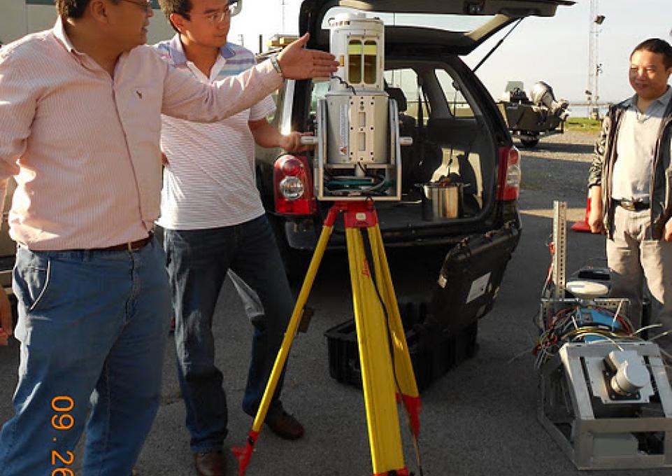
The data is unique because it is three-dimensional, thanks to the use of LIDAR technology. Tang explained that the acronym comes from the phrase “light detection and ranging.” The equipment uses laser beams to scan objects and render a 3-D drawing. The scientists refer to the equipment as “laser scanners.” One is a mobile unit, equipped with a gyroscope; the other is a tripod unit that Zhong brought from Capital Normal, with the help of the two students who accompanied him.
Shumin Wang is a Ph.D. candidate in GIS studies at Beijing Normal; Guangwei Li is a master’s student. Both work with Zhong in the National Laboratory for Three-Dimensional Studies at Capital Normal.
“By acquiring 3-D data,” explained Tang, “we have another way to focus on the interaction between the near-shore area of Lake Erie and the features on the shore, including vegetation cover, land use, and incoming waterways.”
“The laser scanner from Capital Normal had its own passport,” explained Wang. “There is an international treaty that allows scientific researchers and medical personnel to bring the equipment they need to and from countries who have signed the treaty.” Both China and the United States are signatories.
To acquire the data—which basically creates a 3-D map of the shoreline—the team is operating out of the Great Lakes Center Field Station on the Niagara River. With the help of Mark Clapsadl, field station manager, they load the equipment onto a suitable available boat and launch either from the field station or from a launch site closer to the shoreline under investigation. It is usually more efficient to trailer the boat to other sites on Lake Erie, such as the Cattaraugus Creek.
“We want to obtain real-life, 3-D information,” explained Zhong, who is an expert in the use of laser-scanning equipment. The team alternates between the two models. The tripod has a longer range—about 800 meters.
“I wanted to put this collaboration together because I believe that collecting 3-D data can benefit not just Lake Erie research, but also local governments,” said Tang. “I hope that we can contribute to a 3-D database for use by the public and private sectors.” Many municipalities have enhanced their GIS systems with 3-D information collecting using LIDAR technology.
The team has also received funding for a small project for the New York State Thruway Authority, which has shown interest in the technology’s potential. A pilot project will be conducted along the I-190 section of the New York State Thruway and the I-90 from exit 53 (Buffalo) to exit 57 (Hamburg).